If you’re searching for a black hills hiking guide, you’ve come to the right place. Nestled in western South Dakota and stretching into northeastern Wyoming, the Black Hills rise dramatically from the Great Plains, offering over 450 miles of trails through pine forests, granite spires, sacred peaks, and historic canyons. From the summit of Black Elk Peak—the highest point east of the Rockies at 7,242 feet—to hidden waterfalls and century-old mining paths, this region delivers unparalleled hiking diversity just a short drive from Rapid City. Whether you’re a beginner seeking a shaded forest loop or an experienced backpacker chasing solitude on the 125-mile Centennial Trail, this black hills hiking guide equips you with everything you need: top trail picks by region, seasonal advice, safety essentials, navigation tools, and cultural insights to ensure your adventure is safe, respectful, and unforgettable.
Northern Black Hills: Hike Canyons, Mines & Historic Rails
The northern Black Hills offer cooler temperatures, lush greenery, and fewer crowds—ideal for hikers seeking history, geology, and refreshing creek crossings.
Conquer Devil’s Bathtub & Spearfish Canyon Waterfalls
Spearfish Canyon’s steep limestone walls shelter some of the most scenic short hikes in the region. The Devil’s Bathtub (1.6 miles round-trip) is a favorite summer destination—a natural rock waterslide carved by Whitewood Creek. Expect boulder-hopping and creek crossings; avoid this trail during or after rain due to flash flood risk. Nearby, the Roughlock Falls Trail (0.5 miles) offers an easy, paved path to a 70-foot cascade, perfect for families. Spring delivers peak water flow, while winter transforms the falls into glittering ice sculptures.
For geology lovers, the Silica Mines Trail near Deerfield Lake leads to abandoned quartz mines. This lesser-known path provides a quiet, educational hike through mining history with minimal elevation gain.
Walk the Homestake Railroad Grade to Gold Run Park
Follow the gentle 3-mile trail between Lead and Deadwood along the old Homestake Railroad bed. With a nearly flat grade, it’s ideal for beginners, trail runners, or families. Interpretive signs detail the 1870s gold rush, and the path connects to Gold Run Park, a 0.8-mile interpretive loop featuring restored mining equipment and educational displays—perfect for kids.
Southern Black Hills: Summit Peaks & Explore Custer State Park
Home to Mount Rushmore, Wind Cave, and Black Elk Peak, the southern Black Hills deliver the most iconic and challenging hikes in the region.
Summit Black Elk Peak: A Hike to South Dakota’s Highest Point

Standing at 7,242 feet, Black Elk Peak is not just a summit—it’s a pilgrimage. Multiple trailheads offer different challenges:
– Sylvan Lake to Summit Loop (7.1 miles): The most popular route, this moderate trail gains 1,459 feet and passes through the dramatic Cathedral Spires.
– Little Devils Tower Trailhead (6.4 miles): Quieter access with fewer hikers, ideal for sunrise or weekday hikes.
– Cathedral Spires Trail (6 miles): Rocky and rugged—best for experienced hikers.
The summit features a CCC-built stone lookout tower from the 1930s and panoramic views across four states on clear days. As a sacred site in Lakota tradition (Hinhan Kaga), hikers are encouraged to practice quiet reflection and avoid drones or loud music.
Pro tip: Arrive by 6:30 a.m. in summer to avoid crowds and afternoon thunderstorms.
Climb Little Devils Tower & Cathedral Spires

Just a short drive from Sylvan Lake, Little Devils Tower (3.1 miles out-and-back) offers a Class 3 scramble—hands-on climbing required—for breathtaking views of the prairie and Black Elk Peak. Not for those with a fear of heights.
Nearby, the Cathedral Spires Trail (1.5 miles) winds through towering granite formations, offering a taste of rock climbing terrain without the technical gear. Great as a warm-up or photography stop.
Hike Lover’s Leap, Sunday Gulch & St. Elmo’s Peak
For rugged terrain and solitude, try:
– Lover’s Leap Loop (3 miles): Named after a tragic Lakota love story, this trail features ridge walking, creek crossings, and sweeping views. Use trekking poles on slippery rocks.
– Sunday Gulch Loop (4 miles): Begins with a steep descent over boulders and handrails—don’t be fooled by the safety features; this is a challenging hike with rewarding vistas.
– St. Elmo’s Peak (1.8 miles out-and-back): A brutal 1,200-foot elevation gain in under a mile makes this a favorite training ground for the Tatanka Hotshots. Wear long pants—poison ivy grows along the trail.
Rapid City Area: Urban-Adjacent Hikes for Quick Escapes
Just minutes from city amenities, these trails offer accessible nature without the long drive.
Buzzards Roost, Coon Hollow & the Flume Trail
- Buzzards Roost (2.9 miles): A scenic, easy loop with switchbacks to reduce erosion. Popular with runners and mountain bikers, it offers great views with minimal effort.
- Coon Hollow Loop (3.3 miles): A peaceful forest hike through pine and aspen, praised for its serenity and wildlife sightings—deer, turkeys, and chipmunks are common.
- Flume Trail (11–12 miles one-way): Originally built in the 1880s to carry water to gold mines, this shaded canyon trail now offers wildflowers, creek crossings, and historic flume remnants. The 3–4.5-mile Loop A includes a narrow tunnel and is best hiked in dry weather—mud is common in spring.
Wyoming Extension: Sacred Sites & Geological Wonders
Just across the border, these trails blend spirituality and natural spectacle.
Hike Bear Butte (Mato Paha)
Near Sturgis, Bear Butte State Park protects a sacred Lakota site. The 3.7-mile round-trip trail climbs to 4,426 feet with prayer cloths lining the path—do not touch or remove them. On clear days, you can see four states. Part of the Centennial Trail, it’s a spiritually significant hike requiring quiet respect.
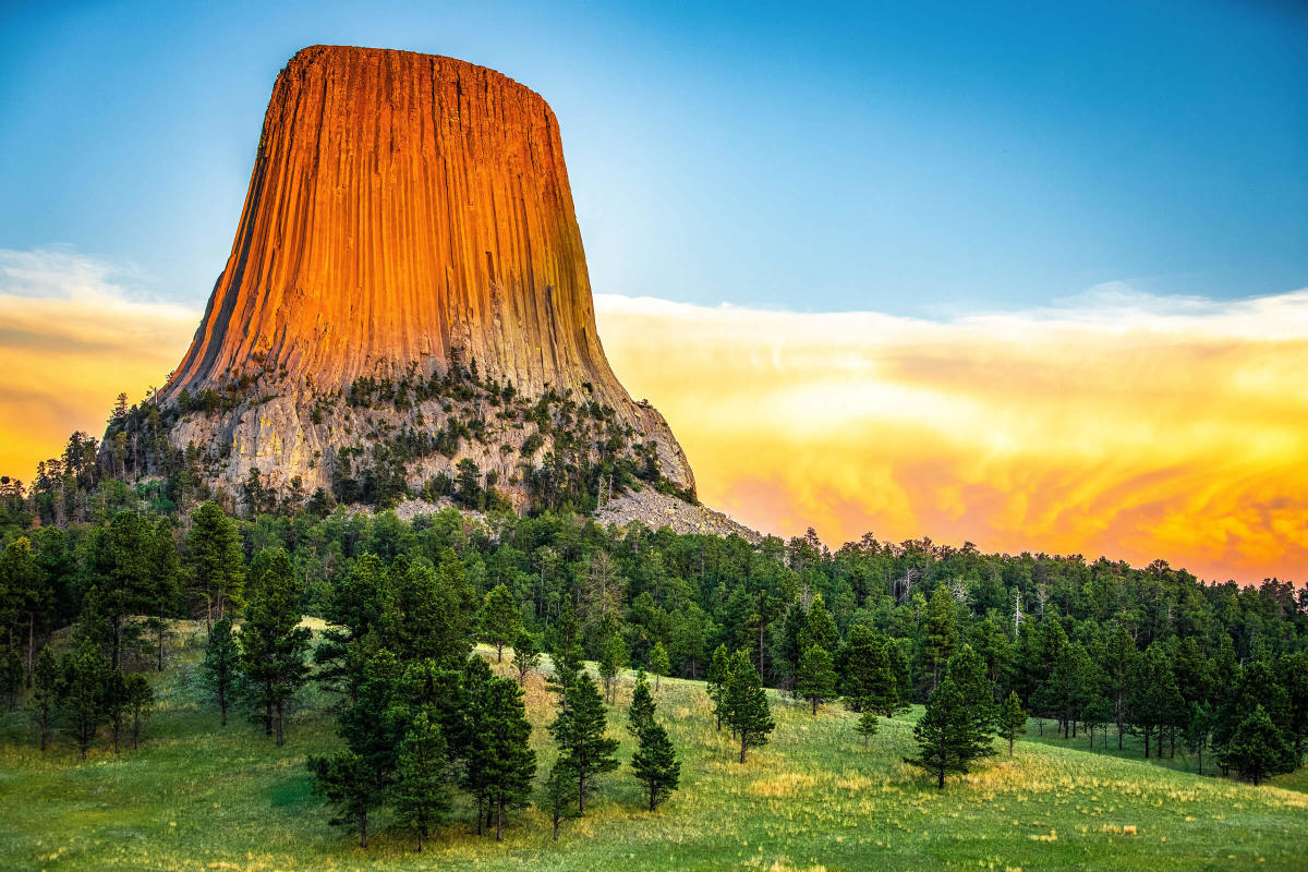
Visit Devils Tower National Monument
A short drive west, Devils Tower (1.3-mile Tower Trail) circles the base of the world’s largest igneous intrusion. No summiting is allowed—this is a protected cultural site. The trail is family-friendly and offers incredible photo ops, especially at sunrise.
Long-Distance & Backpacking Adventures
For multi-day treks, the Black Hills offer two epic trails.
Hike the Centennial Trail (125 Miles)
Spanning from Bear Butte to Wind Cave, this rugged trail crosses prairies, forests, and ridges with 13,412 feet of elevation gain—more than most mountain trails. With 21 access points, it’s ideal for section hiking or thru-hiking. Dispersed camping is allowed in national forest zones; some campgrounds require reservations. Hikers report complete solitude, even on weekends.
Try the Sanctuary Loop in Wind Cave
This 12-mile loop combines the Centennial and Sanctuary trails, offering high chances of seeing bison, pronghorn, and prairie dogs. Isolated and peaceful, it’s perfect for those seeking raw, untouched nature.
Walk the George S. Mickelson Trail
Though shared with bikers and equestrians, this 109-mile crushed limestone trail follows a former railroad. With 100+ trestle bridges and 4 tunnels, it’s ideal for families, dogs, and casual walkers. Rent bikes or use shuttles in Hill City to hike partial sections.
Trail Planning & Navigation Tools
With spotty cell service, smart navigation is critical.
Use the 2024 Black Hills Hiking & Biking Guide
Published by Trail Addict, this free guide includes:
– 90+ trails with QR codes for turn-by-turn directions
– Elevation profiles and regional maps
– Free digital download at TrailAddict.com/guides
– Printed copies at visitor centers
For advanced users, Trail Addict+ offers GPX downloads and discounts.
Carry Backup Navigation
- AllTrails app: Download offline maps before you go
- GPS device or compass: Trail markers can be sparse
- FalconGuide Book: Hiking the Black Hills Country offers rich narratives—but verify distances with GPS, as some trails are misreported
Seasonal Hiking Tips
Each season brings unique conditions.
- Spring: Trails are muddy; ticks are active. Best hikes: Flume, Roughlock Falls. Wear gaiters.
- Summer: Hike at sunrise to beat heat and crowds. Thunderstorms roll in by afternoon—carry rain gear.
- Fall: Late September to October brings golden aspens and fewer bugs—perfect for photography.
- Winter: Trails like Devil’s Bathtub and Flume offer frozen waterfalls and solitude. Bring microspikes and insulated boots.
Safety & Gear Checklist
Stay safe with smart preparation.
Essential Rules
- Keep 100+ yards from bison and elk
- Carry bear spray (black bears are rare but present)
- Use trekking poles for creek crossings
- Poison ivy grows on St. Elmo’s Peak—“Leaves of three, let it be”
- No cell service in remote areas—download maps and share your route
Must-Pack Gear
- Sturdy hiking boots with ankle support
- Layered clothing (moisture-wicking base, insulating mid, waterproof outer)
- Sun protection: hat, sunglasses, sunscreen
- First aid kit, headlamp, snacks, water filter
- Bear spray (recommended for backcountry)
Cultural & Spiritual Hikes
Respect sacred sites.
- Bear Butte (Mato Paha): Do not touch prayer cloths or fly drones. Hike quietly.
- Black Elk Peak (Hinhan Kaga): Site of Black Elk’s vision. Practice quiet contemplation.
Final Tips for a Great Hike
- Start easy: Try Coon Hollow or Gold Run Park if new to hiking
- Hike with a partner: Especially on remote trails like Centennial
- Leave No Trace: Pack out trash, stay on trail
- Support local: Buy the Trail Addict guide or grab a post-hike beer at Crow Peak Brewing
- Check conditions: Visit Black Hills National Forest for closures
The Black Hills offer a rare blend of natural beauty, cultural depth, and trail variety. With this black hills hiking guide, you’re ready to explore safely, respectfully, and with confidence.
Plan your hike. Respect the land. Embrace the journey.